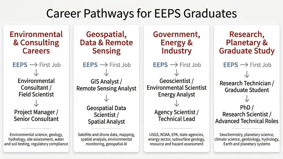
EEPS students develop a combination of field, analytical, and quantitative skills that are directly applied in environmental consulting, geospatial analysis, government science, energy, and research careers.
Core skills developed in the EEPS major include:
- Field data collection and environmental measurement
Applied in environmental consulting, hydrology, geology, and government science (e.g., site assessment, water and soil sampling, environmental monitoring)
- Geospatial analysis and remote sensing
Applied in GIS and geospatial careers using satellite and drone data, mapping, and spatial analysis
- Quantitative analysis and data interpretation
Applied in environmental modeling, climate analysis, and data-driven decision making
- Earth system and geologic understanding
Applied in environmental assessment, resource evaluation, hazard analysis, and energy-related work
- Laboratory and geochemical analysis (for many students)
Applied in research, environmental chemistry, geochemistry, and laboratory-based careers
EEPS graduates are prepared for careers across environmental consulting, geospatial and data-driven fields, government agencies, energy and natural resources, and research.
Many of these skills are also increasingly important in the emerging AI-driven economy. Modern environmental science relies on large datasets from satellites, sensor networks, laboratory instruments, and numerical models. EEPS students learn how to collect, analyze, and interpret these complex datasets - skills that translate directly to modern data science and AI-assisted analysis.
For example, satellite remote sensing, environmental monitoring networks, and geospatial analysis are now widely integrated with machine learning tools to detect environmental change, model climate and water systems, and support decision-making in government, industry, and research.
Demand for expertise in environmental data, geospatial analysis, and Earth system science continues to grow across both the public and private sectors, particularly in areas such as climate, water resources, natural hazards, and geospatial technology.